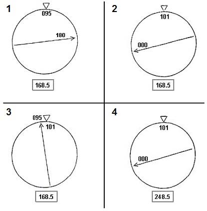
ATPL: The inertial navigation system (INS) indicates: Position: 71° 55.1'N 094°55.3'WDrift: 6°L (left)The route followed in order to return to the VOR station is the meridian of the VOR station used:RESOLUTE BAY (74°43.6'N 094°55.3W), this VOR has North set on the local geographic meridian.The gyro compass has just been reset to Grid North (chart used: polar stereographic chart, grid parallel to zero meridian, Grid North in the direction of geographic North Pole).The correct representation of the RMI VOR/DME is at this moment: (the distance DME is in the box)
Question 158, Operational Procedures - ATPL - Airline Transport Pilot license
Explanation: The inertial navigation system (INS) indicates: Position: 71° 55.1'N 094°55.3'WDrift: 6°L (left)The route followed in order to return to the VOR station is the meridian of the VOR station used:RESOLUTE BAY (74°43.6'N 094°55.3W), this VOR has North set on the local geographic meridian.The gyro compass has just been reset to Grid North (chart used: polar stereographic chart, grid parallel to zero meridian, Grid North in the direction of geographic North Pole).The correct representation of the RMI VOR/DME is at this moment: (the distance DME is in the box)